")

")


eTrex Touch 35
IQD 450.000
PART NUMBER 010-01325-11
2 in stock
Overview
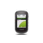
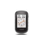
Compact, rugged and reliable GPS/GLONASS handheld with color touchscreen, featuring a barometric altimeter and 3-axis tilt-compensated electronic compass, wireless connectivity, preloaded geocaches and expanded internal memory to hold more maps.
eTrex Touch 35 features a sunlight-readable, 2.6-inch color touchscreen display offering intuitive access to worldwide basemap with shaded relief. Durable and water resistant, eTrex Touch 35 is built to keep delivering vital mapping and tracking data no matter what the elements throw at you, standing strong against dust, dirt, humidity and water.
eTrex Touch 35 features a built-in 3-axis tilt-compensated electronic compass that shows your heading even when you’re standing still, and you don’t have to hold it level. Also added is a barometric altimeter, which tracks changes in pressure to pinpoint your precise altitude, and you can even use it to plot barometric pressure over time, which can help you keep an eye on changing weather conditions.
With an array of compatible mounts, eTrex Touch 35 is designed for use on ATVs, bicycles, boats, as a handheld or in your car. Use the auto mount capability and City Navigator® NT maps for turn-by-turn driving directions, or the rugged mount for your motorcycle or ATV. Wherever you think you might take eTrex, it has the mapping and mounts to get you there.
eTrex Touch 35 can track both GPS and GLONASS satellites simultaneously. Developed by the Russian Federation, GLONASS satellites “lock on” to a position (on average) approximately 20 percent faster than GPS receivers. Using both GPS and GLONASS means the receiver has the ability to lock on to 24 more satellites than using GPS alone.
With its microSD™ card slot and an expandable internal memory, eTrex Touch 35 lets you load TOPO maps and hit the trail, plug in BlueChart® g preloaded cards for a great day on the water or City Navigator NT map data for turn-by-turn routing on roads.
eTrex Touch 35 lets you share your waypoints, tracks, routes and geocaches wirelessly through unit-to-unit sharing to compatible Garmin devices. The smart notification feature means you’ll never miss a text, email or notification from your compatible smartphone*, unless you want to. Keep Your FixWith its high-sensitivity, WAAS-enabled GPS receiver and HotFix® satellite prediction, eTrex Touch 35 locates your position quickly and precisely and maintains its GPS location even in heavy cover and deep canyons.Find FuneTrex Touch 35 is preloaded with 250,000 geocaches from Geocaching.com. By going paperless, you're not only helping the environment, but also improving efficiency. eTrex Touch 35 stores and displays key information, including location, terrain, difficulty, hints and descriptions, which means no more manually entering coordinates and paper printouts. Simply upload the GPX file to your unit and start hunting for geocaches.*Phone must be Bluetooth Smart. See Garmin.com/BLE for compatibility.iPhone is a trademark of Apple Inc. Android is a trademark of Google Inc.
With its high-sensitivity, WAAS-enabled GPS receiver and HotFix® satellite prediction, eTrex Touch 35 locates your position quickly and precisely and maintains its GPS location even in heavy cover and deep canyons.
eTrex Touch 35 is preloaded with 250,000 geocaches from Geocaching.com. By going paperless, you're not only helping the environment, but also improving efficiency. eTrex Touch 35 stores and displays key information, including location, terrain, difficulty, hints and descriptions, which means no more manually entering coordinates and paper printouts. Simply upload the GPX file to your unit and start hunting for geocaches.
*Phone must be Bluetooth Smart. See Garmin.com/BLE for compatibility.iPhone is a trademark of Apple Inc. Android is a trademark of Google Inc.
Reviews
There are no reviews yet.